
Beginning on Thursday afternoon, Mullen Fire grows to nearly 14,000 acres over the weekend leading to evacuations
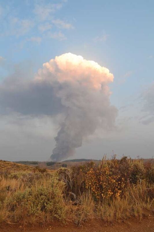
The sun brilliantly illuminates the billowing smoke giving momentary beauty to the destruction taking place over the next hill.
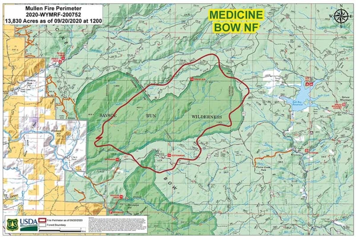
A fire map from Sunday afternoon shows the borders of the Mullen Fire in relation to the Savage Run Wilderness. As of Tuesday, a Type II Incident Management Team has taken over the fire.
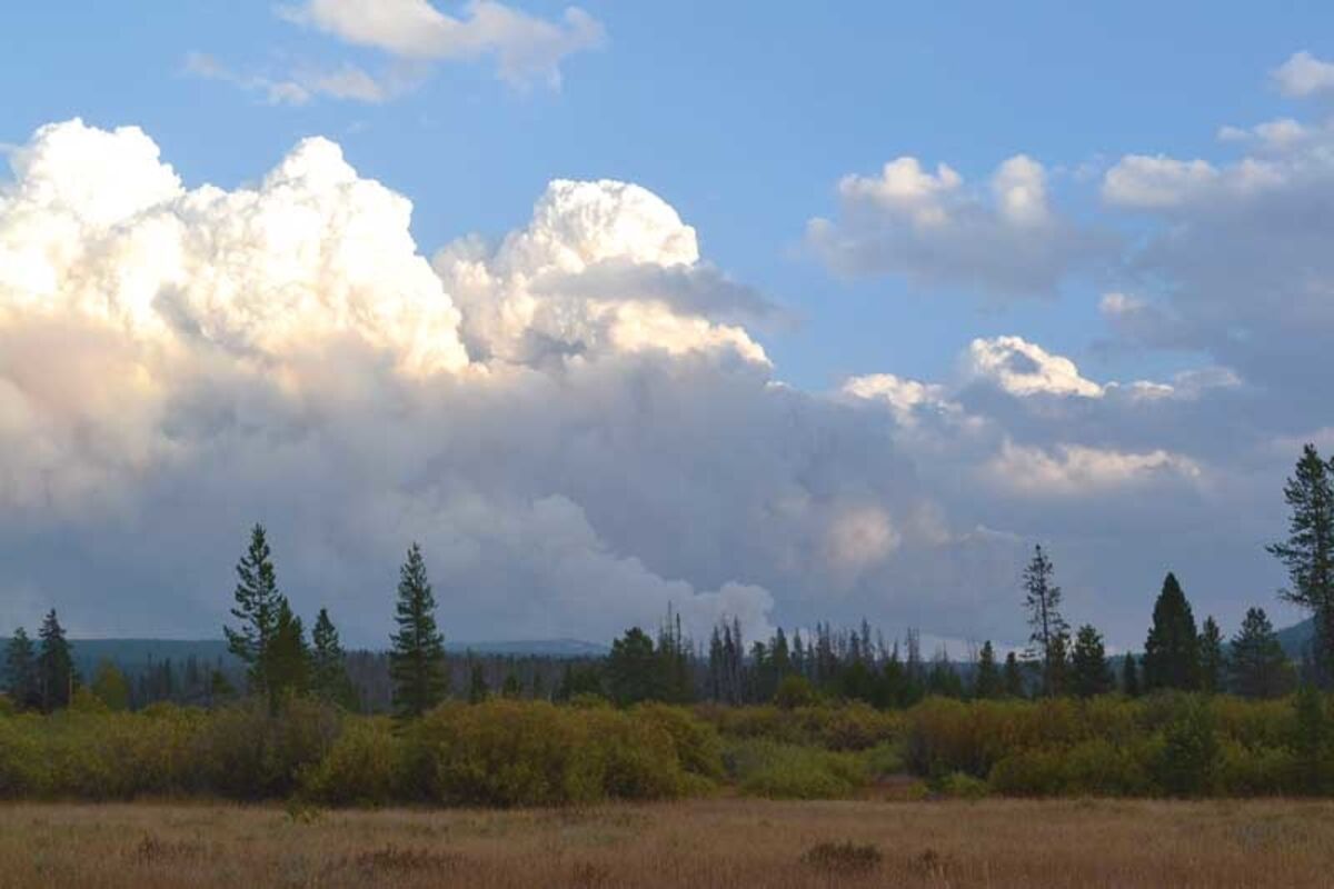
Smoke could be seen surging up into the sky near Ryan Park on Saturday.
High winds and warm temperatures over the weekend worked in favor of the recently established Mullen Fire, which had consumed much of the Savage Run Wilderness over the weekend and put several communities at risk.
As of Monday morning, the fire had grown to 13,835 acres and was two percent contained.
At approximately 3 p.m. on Thursday, local volunteer fire departments were called to respond to a fire east of the A-Bar-A Guest Ranch outside Encampment. While multiple fire engines did respond to the area and set-up on the eastern edge of the A-Bar-A, the nature of the wilderness area provided some difficulty.
The nearly 15,000 acres wilderness area located in the Medicine Bow-Routt National Forest is off-limits to motorized vehicles. The area also provided plenty of fuel load for the Mullen Fire as it was one of the many areas in the national forest that had been affected by the bark beetle epidemic nearly a decade ago.
While the Encampment Volunteer Fire Department, Saratoga Volunteer Fire Department and Ryan Park Volunteer Fire Department responded alongside the United States Forest Service (USFS), they could not enter the wilderness area with their fire engines. This left aerial attack as the only option. The single-engine air tankers and the Type 3 and Type 1 helicopters that initially responded, however, were limited to water as chemical fire retardant could not be used in the wilderness area.
While an Initial Attack Hand Crew had responded on Thursday evening, according to Carbon County Fire Warden Ron Brown, USFS Public Information Officer Aaron Voos informed the Saratoga Sun that they would not engage with the fire unless it was deemed safe to do so. As of Thursday evening, the grounds crews were aiding in coordinating the aerial attack of the Mullen Fire.
By Thursday evening, the fire had grown to 80 acres but would more than double in size overnight to 200 acres on Friday morning. The rapid fire growth led to the USFS issuing their first area closure and evacuations of the Rob Roy Reservoir and the Rambler Subdivision. The fire had more than tripled in size by Friday afternoon, growing to 644 acres in size. By Friday night, the Mullen Fire had increased, again, to 2,000 acres.
Saturday morning saw yet another increase, as the fire grew overnight from 2,000 acres to 3,855 acres. Speaking with Brown on the morning of September 19, he informed the Saratoga Sun that additional air and ground resources were incoming and that two fuel breaks had been established along Forest Road 500 and Forest Road 512.
With red flag warnings in place, however, Brown added that there was potential for significant fire growth. The Sun also spoke with Voos on Saturday morning, who added on to Brown's report stating that single-engine air tankers were working along Forest Road 512 as the fire approached it and there was discussion about setting fire retardant along Forest Road 511.
Additionally, aerial and ground crews were attacking the western edge of the fire at the A-Bar-A Guest Ranch and had been successful in keeping that fire line in check. Though the western edge was in check, the opposite edge of the Mullen Fire was moving in eastern, northeastern and southeastern directions.
Voos also stated that, due to the rapid growth of the fire, it was proving difficult to map. On Saturday morning, while it was evident that the Mullen Fire was approaching Rambler, it was unclear how close it was to the subdivision due to the high winds and the large column of smoke directly over the fire.
Saturday evening saw yet another dramatic increase in size as the fire grew to 7,000 acres. By that point, the USFS had brought in additional aerial resources including a VLAT (Very Large Air Tanker) and multiple LATs (Large Air Tanker). Both the VLAT and the LATs were using a combination of water and retardant to protect the Rambler area from the fire. Meanwhile, the fire had moved beyond Forest Road 511 and out of the wilderness area.
The strong and shifting winds on Saturday, which brought in a much needed rain storm, forced aerial crews to pull back from their attack on the Mullen Fire. Due to that, the USFS was unable to provide an updated size of the fire on the evening of September 19, though it was estimated the fire had increased, again.
The closure order issued on Friday evening was updated on Saturday evening with an increased perimeter that extended to the eastern edge of the national forest and up to Wyoming Highway 130 and the Snowy Range.
Despite the rain storm Saturday night, mapping on Sunday morning put the fire at 13,835 acres. The increased size of the fire also led to the evacuation of the Keystone area. Strong winds and the movement of the Mullen Fire also led Albany County Emergency Management to put Centennial Valley on pre-evacuation notice. This included the communities of Centennial and Albany and private landowners along Fox Creek Road.
Monday morning saw the fire at two percent containment and still at 13,835 acres in size. The aerial attacks on the east and southeast edge of the fire prevented it from moving into Rambler and the two percent containment was due to aerial and ground crews working on the western end of the fire. A red flag warning and high winds, however, were still in effect on Monday with the potential of more fire growth.
As of Monday morning, it was expected that the fire would make a run up Mullen Creek headwaters and into Douglas Creek and Middle Fork Little Laramie.
Up-to-date information can be found at www.saratogasun.com and at https://inciweb.nwcg.gov/incident/7208/.
On Tuesday morning, a Type II incident management team had taken command of the fire.
Reader Comments(0)